About Marine Navigation
MARINE NAVIGATION Find your way on the sea with ease! Our GPS chartplotter for boating is an easy-to-use offline GPS tracker and route planner featuring worldwide offline maps. Whether you're a seasoned sailor, a...
MARINE NAVIGATION
Find your way on the sea with ease! Our GPS chartplotter for boating is an easy-to-use offline GPS tracker and route planner featuring worldwide offline maps.
Whether you're a seasoned sailor, a fisherman, or just love water sports, this app is dedicated to the sea and the people who love it.
WHAT MAKES IT THE BEST GPS TRACKER AND NAVIGATOR:
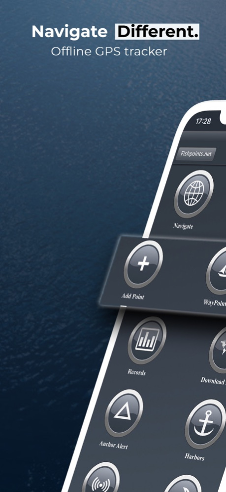
Offline GPS tracker for boat navigation. GPS chartplotter for sailing and boating.
Morse Code in case of danger, Anchor Alert to prevent the drift of the anchor, and Moon Phase to show the phases of the moon during the day.
Harbors feature to see the list of ports.
Sync Waypoints feature to be able to create backups and access them from different devices.
Download the maps and marine charts, so you won't need an active internet connection for navigation and route planning.
Create a profile to save waypoints and routes, and access them from different devices.
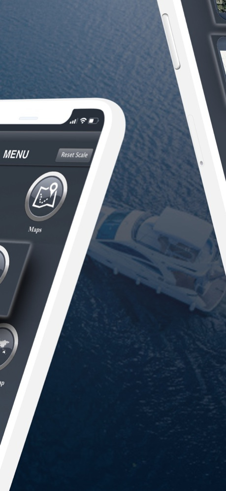
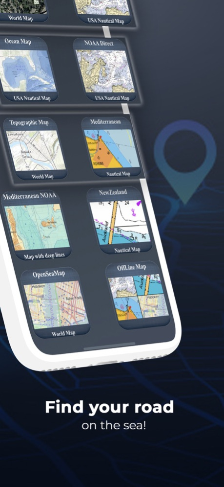
MAPS OFFLINE:
Download maps or marine charts to navigate on preloaded maps or charts without a connection.
MAPS AND MARINE CHARTS:
Nautical maps of the United States of America by NOAA.
Nautical maps of the Mediterranean by NOAA.
Mediterranean RNC.
Nautical maps of New Zealand by LINZ.
Maps of the world's oceans and coastal areas by ESRI.
World topographic map includes boundaries, cities, water features, ports, physiographic features by ESRI.
Satellite imagery for the world by ESRI.
Maps for the sea, with ports, sea lights, and more by Open Sea Map.
Beta Nautical maps by Fishpoints
MAIN FEATURES:
Super easy-to-use GPS tracker tool with a clean and neat design.
Weather feature.
GPX Import and Export.
Available in English, Italian, French, Spanish, Brazilian, Turkish, German, and Indonesian.
Download Maps to use in offline mode.
Accurate and detailed GPS Chartplotter, GPS plotter, and Marine charts.
Optimized for phones and tablets.
Receive information about speed, direction, and time to arrival.
Compass Magnetic or True.
Change Measurement Units: Km, Mi, or Nmi.
Record your route to analyze the data and renavigate your trace.
LOCATION PERMISSION
The app needs your location to trace the route on the map. Location information is processed locally on your device, ensuring your privacy.
TRY THE FREE VERSION
Get more details about the app by trying our Marine Navigation Lite version.
HELP US IMPROVE
Download Marine Navigation and let us know about any bugs, feature requests, or any other suggestions. Stay tuned for more features and options in this GPS tracker app for boating.
WARNING
Good seamanship requires the use of official charts. Marine Navigation is for use with other charts and cannot replace official charts. Use at your own risk.
LEARN MORE ABOUT FISHPOINTS
Visit our official website or join us on Facebook.
TERMS OF USE: http://www.fishpoints.net/eula/
PRIVACY POLICY: http://www.fishpoints.net/privacy-policy
Mar 18, 2024
Version 9.3.1
Update Esri Maps
Previous Versions
Here you can find the changelog of Marine Navigation since it was posted on our website on 2016-12-30 15:46:55.
The latest version is 9.3.1 and it was updated on 2024-04-22 08:44:13. See below the changes in each version.
Marine Navigation version 9.3.1
Updated At: 2024-03-18
Changes: Mar 18, 2024
Version 9.3.1
Update Esri Maps
Marine Navigation version 8.4.14
Updated At: 2023-04-15
Changes: Apr 15, 2023
Version 8.4.14
Upgrade for new IOS requirements
Bug Fixing
Enhancement Download Interface
Marine Navigation version 7.4.6
Updated At: 2022-04-04
Changes: Apr 4, 2022 Version 7.4.6
Set Accuracy GPS
Improve Background Record Route
Marine Navigation version 6.3.66
Updated At: 2021-10-06
Changes: Oct 6, 2021 Version 6.3.66
BugFix on Route View
Marine Navigation version 6.3.55
Updated At: 2021-08-31
Changes: Aug 31, 2021 Version 6.3.55
•Increase GPS Precision
•Magnetic or True Compass
•Record Route & Normal Route View Information
•Navigation View: Information inside viewfinder
•Navigation View: Reposition to location after map moved
•Navigation View: New Interactive North Icon
Marine Navigation version 6.3.40
Updated At: 2021-08-17
Changes: Aug 17, 2021 Version 6.3.40
BugFixing
Marine Navigation version 6.3.22
Updated At: 2021-07-26
Changes: Jul 26, 2021 Version 6.3.22
-Increase size of GPX Export
Marine Navigation version 6.3.18
Updated At: 2021-04-18
Changes: Apr 18, 2021 Version 6.3.18
- Ports List Offline
- No More Login Needed
- Bug Fix
Marine Navigation version 6.3.18
Updated At: 2021-04-18
Changes: 18 Apr 2021 Version 6.3.18
- Ports List Offline
- No More Login Needed
- Bug Fix
Marine Navigation version 6.1.28
Updated At: 2021-03-19
Changes: Mar 19, 2021 Version 6.1.28
-Improved map's zoom function
Disclaimer
Official App Store Link
We do not host Marine Navigation on our servers. We did not scan it for viruses, adware, spyware or other type of malware. This app is hosted by Apple and passed their terms and conditions to be listed there. We recommend caution when installing it.
The App Store link for Marine Navigation is provided to you by apps112.com without any warranties, representations or guarantees of any kind, so access it at your own risk.
If you have questions regarding this particular app contact the publisher directly. For questions about the functionalities of apps112.com contact us.